 ADSCivil

ADSCivil Survey - Editing topographic and geotechnical survey data
A complete solution for topographic map editing
01 — ADSCIVIL Survey - Topographic survey software
ADSCivil Survey - Comprehensive topographic map editing software
ADSCivil Survey supports survey engineers throughout their whole workflow, from collecting measurements in the field to producing the finished detailed survey documentation.
The optimal solution for topographic survey work
- A closed-loop workflow: the software covers the full range of topographic survey tasks — reading data, editing it and producing the finished survey documentation — so users need no other software. This keeps data consistent and safe throughout the project.
- Well-structured and convenient: the data processing cycle is logically built and the features are well optimised, while remaining simple and approachable even for new users.
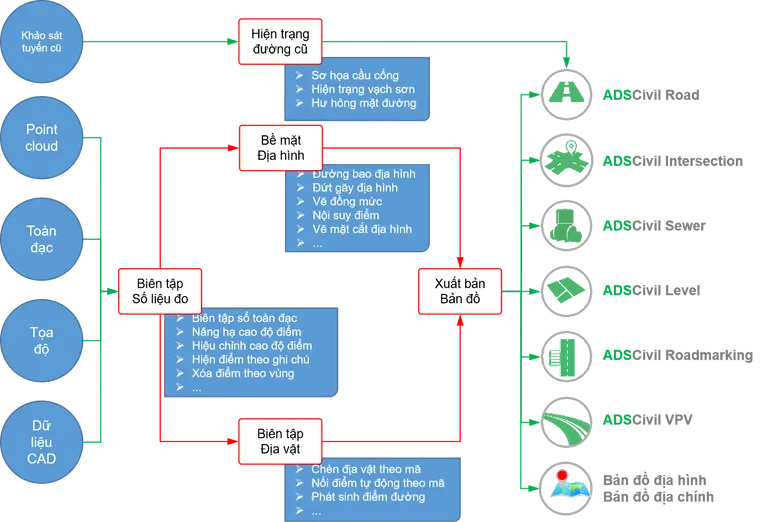
ADSCivil Survey is a comprehensive, powerful and professional solution for all office and field work in topographic surveying.
02 — Overview
Integrating and optimising survey data from multiple methods
ADSCivil Survey edits and standardises every kind of survey data — total station, point cloud, coordinates, digitised cadastral maps and data from CAD software. It allows different measurement methods and instruments to be combined flexibly, and the survey area to be divided so several teams can work simultaneously, optimising resources and speeding up the project. Data can also be split flexibly by area or by measurement method to suit any survey requirement.
Inserting and linking features to reproduce the site
ADSCivil Survey inserts and links features to reproduce the surveyed area accurately. It can join points, filter the display, insert features automatically from a code table, and reference features from the plan onto longitudinal and cross sections. Users therefore have complete feature information with which to optimise the design.
Editing and processing measurement data
ADSCivil Survey provides tools for editing measurement data so errors can be corrected without returning to the field. Features such as transferring points between stations and updating station coordinates resolve data discrepancies, saving cost and effort and shortening the project programme.
An accurate terrain surface mesh model
The surface mesh model in ADSCivil Survey reproduces the terrain accurately by triangulation. It handles millions of level points and updates the terrain model directly, for both small and large adjustments. It displays contours and slope directions and helps identify erroneous levels. The software is also compatible with basic AutoCAD objects.
Efficient, automated map production tools
ADSCivil Survey provides standard map frame templates for topographic and cadastral maps to suit a range of needs. Density-based point display control allows a map to be drawn at a large scale and then output at several different scales. Map sheet splitting is automated, saving users time.
A complete foundation for the ADSCivil ecosystem
ADSCivil Survey does more than produce digital maps: it integrates with the rest of the ADSCivil ecosystem to build works surfaces. Key capabilities include building design surfaces that combine existing and design data, and planning surfaces for site grading design.
03 — Benefits
- Comprehensive and approachable: meets the full range of topographic survey needs, in the office and in the field, even for new users.
- Greater productivity and efficiency: automates the workflow, reduces errors and saves cost.
- Optimised resources: supports splitting and combining data from multiple teams and survey methods.
- Strong integration: links closely with the rest of the ADSCivil ecosystem, creating a consistent data foundation for design and planning projects.
04 — Features
Integrating and standardising survey data
Consolidating and standardising survey data from different methods
ADSCivil Survey edits and standardises every kind of survey data, ensuring accuracy and allowing survey methods to be combined flexibly, including:
- Total station survey data
- Point cloud survey data
- Coordinate survey data
- Data digitised from cadastral maps
- Data converted from CAD software such as AutoCAD and MicroStation
Support for multi-method surveying
The software combines different measurement methods and instruments flexibly, allowing the project's survey area to be divided so several teams can work at once. This optimises the company's resources and speeds up the project, which matters most when the programme is tight.
Flexible, efficient data separation
ADSCivil Survey offers a range of options for splitting data:
- Assign a separate measurement method to each survey area.
- Combine several measurement methods within the same area.

Efficient measurement data editing
Errors can arise while collecting measurements, particularly discrepancies between stations, which lead to inaccurate results for detail points. Rather than returning to the field at cost and delay, ADSCivil Survey provides tools to edit and process the data and correct the errors, including:
- Transferring points between stations.
- Updating instrument station and backsight coordinates.
Being able to edit the data within the software saves users field time and cost while speeding up project delivery.

An accurate terrain mesh model
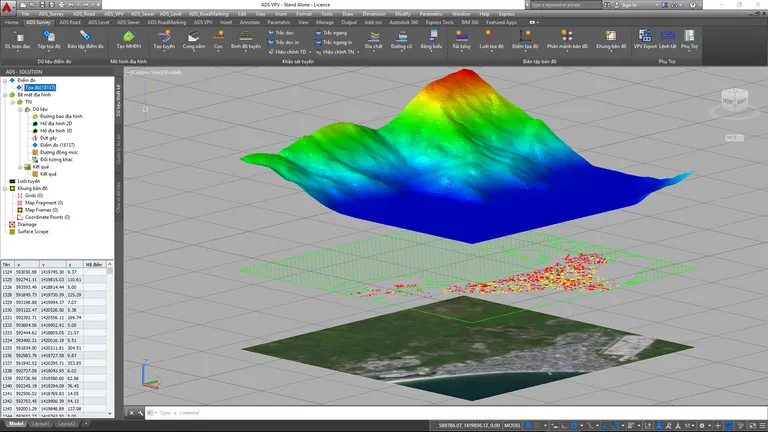
The triangulation engine at the heart of ADSCivil Survey reproduces any real terrain surface accurately. It processes millions of level points at speed and updates the terrain model directly, handling both small changes (edge flips) and large ones (changing the underlying objects). Notable features include:
- Display of breaklines and terrain contours.
- A level colour ramp that makes erroneous level points easy to spot.
- Display of slope direction to support catchment delineation and drainage calculation.
- Support for a wide range of source objects, both ADSCivil and AutoCAD (line, text, point, block, 3Dface and so on).
Inserting, linking and modelling features
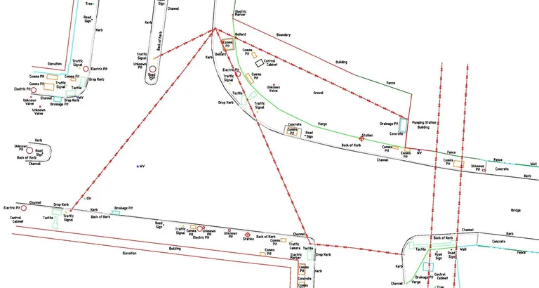
In survey work, inserting and linking features is central to reproducing the surveyed area accurately. ADSCivil Survey provides capabilities that make map editing considerably more productive, such as:
- Automatic point joining by annotation code group.
- Filtering and displaying survey points by code group.
- Automatic feature insertion using a customisable description code table.
- Referencing features from the plan onto the route's longitudinal and cross sections.
With complete information on existing features such as houses, communal houses and temples, the software keeps design options optimal and consistent with the planning boundary.
Automated map production tools
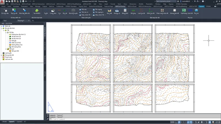
ADSCivil Survey provides standard frame templates for topographic and cadastral maps to suit a range of users. Density-based point display control means the map need only be surveyed and drawn at a large scale, then output at several different scales. Map sheet splitting, which used to take a great deal of time in model view, is now fully automated, saving both time and effort.
Starter
Try it before you decide
Raise the efficiency of your work with ADSCivil Survey — a complete solution that optimises every stage of topographic surveying, from data collection to finished documentation. Get in touch now for a free trial!